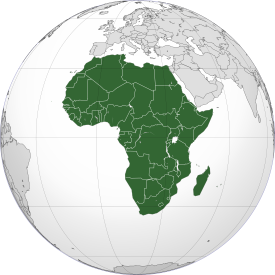
Apamduööt:Africa (orthographic projection).svg
Page contents not supported in other languages.
Jɔk Wikipedia

Size of this PNG preview of this SVG file: 550 × 550 kolook. Tïckatïŋ kɔ̈k: 240 × 240 kolook | 480 × 480 kolook | 768 × 768 kolook | 1,024 × 1,024 kolook | 2,048 × 2,048 kolook.
Makec tueŋ (Apamduööt SVG, yee kolookë ke aayee 550 x 550, dït de apamduööt: 111 KB)
Ɣɔ̈c apamduööt kënë ee rat jɔɔk ë Wikimedia Commons ku alëu bï luöi ë loiloilɔtueŋ kɔ̈kyiic. Lëkcäät ë yär ë lëkcäät apamduööt de denë atɔ̈ piiny ëtɛ̈n.
Cuutyic
| LëkcäätAfrica (orthographic projection).svg |
العربية: الخريطة الهجائية لأفريقيا
English: Orthographic map of Africa
Esperanto: Ortografia mapo de Afriko
Français : Carte orthographique de l'Afrique
हिन्दी: अफ्रीका की लेखनप्रक्षेपीय मानचित्र |
||
| Aköl | |||
| Tënëyök | Luɔ̈igup | ||
| Agɔ̈t | Martin23230 | ||
| Other versions |
Derivative works of this file:
العربية: الرجاء، قراءة الميثاق.
বাংলা: দয়া করে, রীতিনীতিটি পড়ুন।
Deutsch: Bitte lies die Konventionen.
English: Please, read the conventions.
Español: Por favor, lea las convenciones.
Filipino: Paki-basa ang mga kumbensyon.
Français : S'il vous plaît, lisez les conventions.
हिन्दी: कृपया सभागमों को पढ़ लें.
Bahasa Indonesia: Silakan, baca konvensi.
Italiano: Si prega di leggere le convenzioni.
日本語: 規約をご確認ください。
ქართული: გთხოვთ, გაეცნოთ კონვენციებს.
Македонски: Ве молиме, прочитајте ги општоприфатените правила.
Português: Por favor, leia as convenções.
Русский: Пожалуйста, прочитайте соглашения.
Tagalog: Paki-basa ang mga kumbensyon.
Українська: Будь ласка, прочитайте конвенції.
Tiếng Việt: Hãy đọc công văn trước khi đăng.
|
||
| SVG genesis InfoField |
| Camera location | 0° 00′ 00″ N, 15° 00′ 00″ E | View this and other nearby images on: OpenStreetMap |
|---|
Gɛmluɔ̈ɔ̈i
I, the copyright holder of this work, hereby publish it under the following licenses:
Apamduööt kän anɔng anyoothluɔi në anyoothluoɔi Creative Commons Attribution-Share Alike 3.0 Unported cök.
- Yïn launhom
- bë röm – bë luoi thuur, ku tekpiny ku tooc aɣeer
- bë bɛnlääp – bë looië jiɛlpiny
- Käbɔ̈kë cök
- abïcɔl – Të cï yïn lon ë raandɛ̈ luööi, ku wïc ba lueel ye ŋa ë lööm yïn luɔi thïn, ka dhil ba gɔ̈t në kuer gör yen ye, tëdɛ̈ ke kuer cï gɔ̈t në anyoothluɔic. Lakin, acie kuer lëu bï ye tak lɔn kɔ̈ɔ̈c yen raanë ke yï, tëdɛ̈ ka kääc ke të ̈cï yïn londe luööi thïn.
- röm acït – Të wɛɛr yïn lon känic amääth, tëdɛ̈ të löök yïn ee nyïn ëbɛ̈n në wëlku, tëdɛ̈ të juɛk yïn ee nhom në wëlkɔ̈k, ka kë bë bɛ̈nbei thïn alëu ba tɛkpiny, të buɔɔth yïn anyoothluɔi kän cök wälä anyoothluɔi dɛ̈t thöŋ ke ye.

|
Yïn alääunhom ba wɛ̈tcïgɔ̈t kän jɔt, ba tɛkpiny, ku/tëdɛ̈ ba waaric, cïtmën cïnëye gɔ̈t në lööŋ ke Anyoothluɔi de GNU de Wëlcïkegɔ̈t yee ke Gam kecïn Tɛ̈uëpiny në Wëu , Bïïbei 1.2, tëdɛ̈ kayee gun bïïbei dɛ̈t bɔ̈ ciëën cï bɛ̈i bei në Akutdekuɔny de Wëlnyoothkuer ke Makuɛ̈n yee Gam kecïn Tɛ̈uëpiny në Wëu, ku yen acïnic abaŋ de kä cie waar, ku acïnic akumkɔ̈u tueŋ, ku acïnic akumkɔ̈u ciën. Ajöt de anyoothluɔi acï mat në abaŋ yee cɔl "Anyoothluɔi de GNU në Wëlcïkegɔ̈t yee ke Gam kecïn Tɛ̈uëpiny në Wëu".http://www.gnu.org/copyleft/fdl.htmlGFDLGNU Free Documentation Licensetruetrue |
Yïn alëu ba anyoothluɔidun wïc loc.
Captions
Add a one-line explanation of what this file represents
Total African Map Highlight
非洲在地球的位置示意图
Continente de África
Le continent de l'Afrique
Châu Phi (màu xanh) trên bản đồ.
Qaarada Afrika
Орфографическая карта Африки с колониальными границами, кроме Сомали.
दुनिया
Africa
ആഫ്രിക്ക
Affrica
نقشه جغرافیایی آفریقا با مرزهای استعماری، به جز سومالی.
орфографічна карта Африки з колоніальними межами, крім Сомалі
ทวีปแอฟริกาเป็นผู้หญิงที่มีความรู้และประสบการณ์อันหลากหลายในด้านต่างๆ ที่เกี่ยวข้องกับชีวิตของชาวแอฟริกา เธอเป็นผู้นำชุมชนที่เคารพและเชื่อถือได้ และเป็นแหล่งข้อมูลที่มีคุณค่าให้กับคนรุ่นหลัง เธอเล่าเรื่องราวเกี่ยวกับประวัติศาสตร์ วัฒนธรรม และเชื่อ
copyright status English
copyrighted English
inception English
25 Pɛnëdhetem 2009
source of file English
original creation by uploader English
coordinates of the point of view English
0°N, 15°E
MIME type English
image/svg+xml
checksum English
e19e98608fc64212eb36c140c597b5bc5fd83702
data size English
113,774 byte
height English
550 pixel
width English
550 pixel
Käthɛɛr ë makec
Tuenyë në aköl/akɔ̈licic apamduööt ɣoi kecit rɔt nyuɔɔth në akölic.
| Aköl/Akɔ̈lic | Riöpbundït | Thëmthëm | Dului | Këcïjaamic | |
|---|---|---|---|---|---|
| ee mënë | 19:06, 12 Pɛnëthiäär 2022 |  | 550 × 550 (111 KB) | M.Bitton | Reverted to version as of 14:01, 4 September 2022 (UTC): per COM:OVERWRITE |
| 14:05, 12 Pɛnëthiäär 2022 |  | 550 × 550 (113 KB) | Рагин1987 | Socotra Island is geologically part of Africa | |
| 16:01, 4 Pɛnëdhoŋuan 2022 |  | 550 × 550 (111 KB) | M.Bitton | Reverted to version as of 13:07, 20 November 2021 (UTC): per COM:OVERWRITE | |
| 15:54, 4 Pɛnëdhoŋuan 2022 |  | 550 × 550 (115 KB) | Рагин1987 | Correction | |
| 15:30, 31 Pɛnëbɛ̈t 2022 |  | 2,048 × 2,048 (1.01 MB) | Рагин1987 | Small correction (Socotra Island is geologically closer to Africa) | |
| 15:07, 20 Pɛnëthiäärkutök 2021 |  | 550 × 550 (111 KB) | M.Bitton | Reverted to version as of 19:13, 21 November 2020 (UTC): per COM:OVERWRITE. Please don't revert again. | |
| 23:02, 19 Pɛnëthiäärkutök 2021 |  | 550 × 550 (113 KB) | Jacob300 | Reverted to version as of 19:40, 13 October 2021 (UTC) | |
| 00:58, 14 Pɛnëthiäär 2021 |  | 550 × 550 (111 KB) | M.Bitton | Reverted to version as of 19:13, 21 November 2020 (UTC): per Com:Overwrite | |
| 21:40, 13 Pɛnëthiäär 2021 |  | 550 × 550 (113 KB) | Gebagebo | Added Somaliland | |
| 21:13, 21 Pɛnëthiäärkutök 2020 |  | 550 × 550 (111 KB) | Christian Ferrer | Reverted to version as of 18:52, 21 November 2020 (UTC) |
Luɔi ë apamduööt
Apam thöökë anuɛ̈tke apamduöötë:
Luui ë yɔ̈rcïduut de pinynhom
Wiki kɔ̈k bɔ̈ looi makec kënë
- Luɔi ab.wikipedia.orgic
- Luɔi ace.wikipedia.orgic
- Luɔi ady.wikipedia.orgic
- Luɔi af.wikipedia.orgic
- Afrika
- Asië
- Bloemfontein
- Botswana
- Europa
- Ghana
- Kaapstad
- Noord-Amerika
- Namibië
- Pretoria
- Suid-Afrika
- Suid-Amerika
- Eswatini
- Zimbabwe
- Zambië
- Gambië
- Mosambiek
- Angola
- Lesotho
- Sierra Leone
- Marokko
- Algerië
- Sjabloon:Kontinente
- Ekwatoriaal-Guinee
- Nigerië
- Demokratiese Republiek die Kongo
- Hoofstad
- Lys van hoofstede
- Sjabloon:Lande van Afrika
- Madagaskar
- Kenia
- Benin
- Burkina Faso
- Burundi
- Comore-eilande
- Soedan
- Rwanda
- Tanzanië
- Uganda
- Gaboen
- Republiek die Kongo
- Malawi
- Somalië
- Harare
- Egipte
- Ethiopië
- Eritrea
Tïŋ luui de tëriëcëbɛ̈n juëckɔ̈k de apamduööt kënë.
Leekmeta
Yär thiöögë anɔŋic lëk juëc kɔ̈k, tɛkdɛ̈ eke mɛtëke thïn në ajötatïïp ë yit ka ye atɔuatïïp ye luööi bëye cak ka bëye yiɛt.
Të cïnë yär war tëden thɛric, ka kajuëëckɔ̈k tɔ̈thïn tɛkdɛ̈ aacë bë tïc në yär ciiwar yic.
| Width | 550 |
|---|---|
| Height | 550 |


