
Apamduööt:OceaniaLocation.svg

Size of this PNG preview of this SVG file: 463 × 236 kolook. Tïckatïŋ kɔ̈k: 320 × 163 kolook | 640 × 326 kolook | 1,024 × 522 kolook | 1,280 × 652 kolook | 2,560 × 1,305 kolook.
Makec tueŋ (Apamduööt SVG, yee kolookë ke aayee 463 x 236, dït de apamduööt: 290 KB)
Cuutyic
| Lëkcäät |
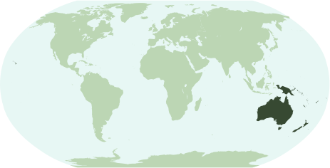
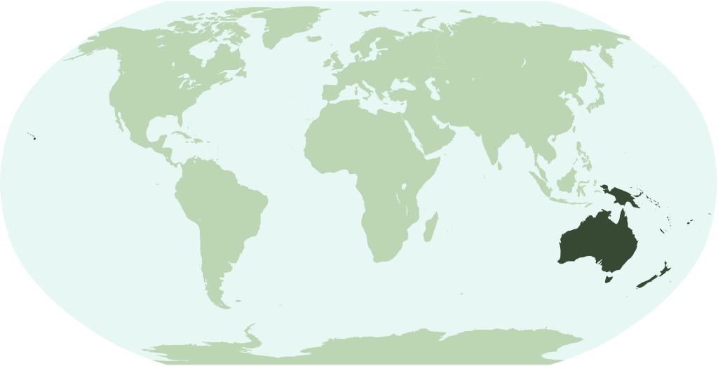
English: Map showing the location of the region/continent of Oceania (including all pacific islands and Hawaii).
Français : Une carte pour démontrer la location de la région (continent) d'Oceanie (avec tous les îles pacifiques et Hawaï).
Interlingua: Un Mapa monstrante le location del region/continente de Oceania (includinte omne insulas pacific e Hawai). |
| Aköl | |
| Tënëyök | Luɔ̈igup |
| Agɔ̈t | Notscott |
Gɛmluɔ̈ɔ̈i
| I, the copyright holder of this work, release this work into the public domain. This applies worldwide. In some countries this may not be legally possible; if so: I grant anyone the right to use this work for any purpose, without any conditions, unless such conditions are required by law. |
Käthɛɛr ë makec
Tuenyë në aköl/akɔ̈licic apamduööt ɣoi kecit rɔt nyuɔɔth në akölic.
| Aköl/Akɔ̈lic | Riöpbundït | Thëmthëm | Dului | Këcïjaamic | |
|---|---|---|---|---|---|
| ee mënë | 01:26, 15 Pɛnëtök 2007 | | 463 × 236 (290 KB) | Notscott | {{en}} Map showing the location of the region/continent of Oceania (including all pacific islands and Hawaii). {{ia}} Mapa monstrante le location del region/continente de Oceania (includinte omne insulas pacific e Hawai). {{fr}} Carte pour démontrer la l |
Luɔi ë apamduööt
Cin apaam ye nuët lɔ wëtmätkën.
Luui ë yɔ̈rcïduut de pinynhom
Wiki kɔ̈k bɔ̈ looi makec kënë
- Luɔi ace.wikipedia.orgic
- Luɔi arz.wikipedia.orgic
- Luɔi avk.wikipedia.orgic
- Luɔi az.wikipedia.orgic
- Papua-Yeni Qvineya
- Yeni Zelandiya
- Kiribati
- Amerika Samoası
- Quam
- Şimali Marian adaları
- Tokelau
- Kokos adaları
- Vanuatu
- Nauru
- Fici
- Yeni Kaledoniya
- Taiti
- Mikroneziya
- Marşall adaları
- Palau
- Avstraliya
- Tuvalu
- Kuk adaları
- Milad adası
- Niue
- Norfolk adası
- Pitkern adaları
- Samoa
- Solomon adaları
- Tonqa
- Uollis və Futuna
- Şablon:Okeaniya
- Avstraliya dolları
- Luɔi bm.wikipedia.orgic
- Luɔi bpy.wikipedia.orgic
- Luɔi cbk-zam.wikipedia.orgic
- Luɔi en.wikipedia.orgic
Tïŋ luui de tëriëcëbɛ̈n juëckɔ̈k de apamduööt kënë.