
Apamduööt:South Sudan topographic map.svg

Size of this PNG preview of this SVG file: 800 × 577 kolook. Tïckatïŋ kɔ̈k: 320 × 231 kolook | 640 × 462 kolook | 1,024 × 738 kolook | 1,280 × 923 kolook | 2,560 × 1,846 kolook | 1,553 × 1,120 kolook.
Makec tueŋ (Apamduööt SVG, yee kolookë ke aayee 1,553 x 1,120, dït de apamduööt: 759 KB)
Cuutyic
| Lëkcäät |
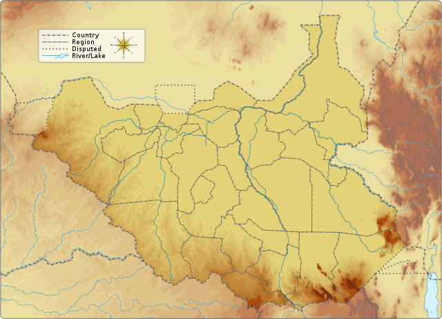
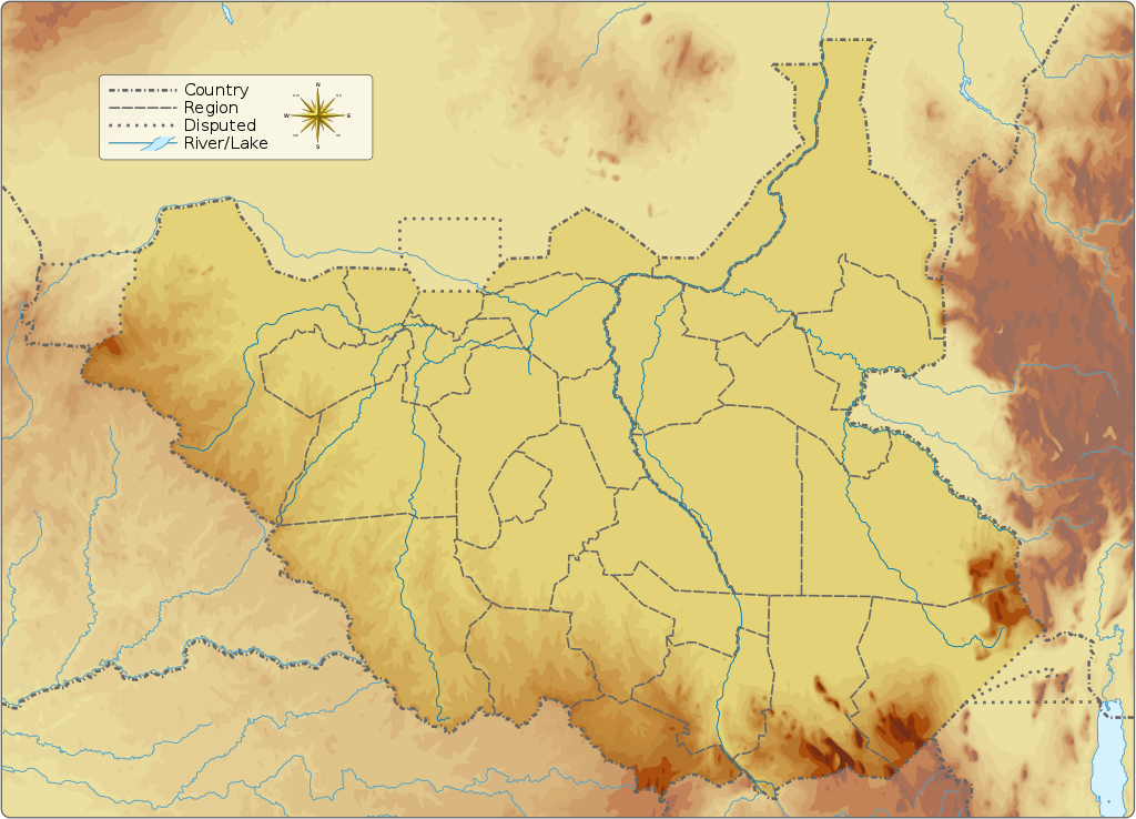
English: Topographic map of South Sudan.
|
||||||||||||||||||||||
| Aköl | |||||||||||||||||||||||
| Tënëyök |
Luɔ̈igup Information from:
|
||||||||||||||||||||||
| Agɔ̈t | Goran_tek-en | ||||||||||||||||||||||
| Kithiɛ̈c (Ke ber wëtmätkën looi) |
This file is licensed under the Creative Commons Attribution-Share Alike 4.0 International license. Abïcɔl: Goran tek-en
|
||||||||||||||||||||||
| Other versions |
|
||||||||||||||||||||||
| SVG genesis | This vector image was created with Inkscape.
|
||||||||||||||||||||||

| Object location | | View this and other nearby images on: OpenStreetMap |
|---|


Gɛmluɔ̈ɔ̈i
This file is licensed under the Creative Commons Attribution-Share Alike 4.0 International license.
Abïcɔl: Goran tek-en
- Yïn launhom
- bë röm – bë luoi thuur, ku tekpiny ku tooc aɣeer
- bë bɛnlääp – bë looië jiɛlpiny
- Käbɔ̈kë cök
- abïcɔl – Të cï yïn lon ë raandɛ̈ luööi, ku wïc ba lueel ye ŋa ë lööm yïn luɔi thïn, ka dhil ba gɔ̈t në kuer gör yen ye, tëdɛ̈ ke kuer cï gɔ̈t në anyoothluɔic. Lakin, acie kuer lëu bï ye tak lɔn kɔ̈ɔ̈c yen raanë ke yï, tëdɛ̈ ka kääc ke të ̈cï yïn londe luööi thïn.
- röm acït – Të wɛɛr yïn lon känic amääth, tëdɛ̈ të löök yïn ee nyïn ëbɛ̈n në wëlku, tëdɛ̈ të juɛk yïn ee nhom në wëlkɔ̈k, ka kë bë bɛ̈nbei thïn alëu ba tɛkpiny, të buɔɔth yïn anyoothluɔi kän cök wälä anyoothluɔi dɛ̈t thöŋ ke ye.
Käthɛɛr ë makec
Tuenyë në aköl/akɔ̈licic apamduööt ɣoi kecit rɔt nyuɔɔth në akölic.
| Aköl/Akɔ̈lic | Riöpbundït | Thëmthëm | Dului | Këcïjaamic | |
|---|---|---|---|---|---|
| ee mënë | 17:32, 5 Pɛnëdhoŋuan 2016 | | 1,553 × 1,120 (759 KB) | Goran tek-en | User created page with UploadWizard |
Luɔi ë apamduööt
Apam thöökë anuɛ̈tke apamduöötë:
Luui ë yɔ̈rcïduut de pinynhom
Wiki kɔ̈k bɔ̈ looi makec kënë
- Luɔi ab.wikipedia.orgic
- Luɔi ar.wikipedia.orgic
- Luɔi av.wikipedia.orgic
- Luɔi az.wikipedia.orgic
- Luɔi be.wikipedia.orgic
- Luɔi bn.wikipedia.orgic
- Luɔi bs.wikipedia.orgic
- Luɔi ceb.wikipedia.orgic
- Luɔi ce.wikipedia.orgic
- Luɔi cs.wikipedia.orgic
- Luɔi de.wikivoyage.orgic
- Luɔi dsb.wikipedia.orgic
- Luɔi el.wikipedia.orgic
- Luɔi en.wikipedia.orgic
- Kidepo River
- Kinyeti
- Lake No
- Bahr el Zeraf
- Pibor River
- Akobo River
- Jur River
- Unity oilfield
- Jikawo River
- Yabus River
- Boma National Park
- Nimule National Park
- Lantoto National Park
- Mbarizunga Game Reserve
- Bengangai Game Reserve
- Southern National Park
- Shambe National Park
- Chelkou Game Reserve
- Imatong Mountains
- Kongkong River
- Kangen River
- Lotilla River
- Kuru River
- Pongo River (South Sudan)
- Wau River
- Didinga Hills
- Daga River (South Sudan)
- Adar River
- Agwei River
Tïŋ luui de tëriëcëbɛ̈n juëckɔ̈k de apamduööt kënë.