Jump to content

Apamduööt:Albania in Europe.svg

Page contents not supported in other languages.
Jɔk Wikipedia

Makec tueŋ (Apamduööt SVG, yee kolookë ke aayee 1,401 x 1,198, dït de apamduööt: 2.61 MB)

Ɣɔ̈c apamduööt kënë ee rat jɔɔk ë Wikimedia Commons ku alëu bï luöi ë loiloilɔtueŋ kɔ̈kyiic. Lëkcäät ë yär ë lëkcäät apamduööt de denë atɔ̈ piiny ëtɛ̈n.

Cuutyic

Lëkcäät
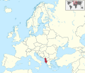
Deutsch: Lage von Albanien in Europa.
English: Location of Albania in Europe.
Aköl
Tënëyök Luɔ̈igup
 
This vector image includes elements that have been taken or adapted from this file:
Europe laea location map.svg (by Alexrk2).
 
This vector image includes elements that have been taken or adapted from this file:
BlankMap-World6.svg (by Canuckguy).
 
This vector image includes elements that have been taken or adapted from this file:
Azerbaijan location map.svg (by Uwe Dedering).
 
This vector image includes elements that have been taken or adapted from this file:
Moldova location map.svg (by NordNordWest).
 
This vector image includes elements that have been taken or adapted from this file:
Cyprus location map.svg (by NordNordWest).
 
This vector image includes elements that have been taken or adapted from this file:
Georgia location map.svg (by NordNordWest).
Agɔ̈t TUBS Gallery
Other versions

This SVG map is part of a locator map series applying the widespread location map scheme. Please see root category to browse for more.

SVG genesis
InfoField
 
The SVG code is valid.
 
This locator map was created with Adobe Illustrator.
 
This SVG locator map was uploaded with Commonist.

Gɛmluɔ̈ɔ̈i

I, the copyright holder of this work, hereby publish it under the following license:
w:en:Creative Commons
abïcɔl röm acït
Apamduööt kän anɔng anyoothluɔi në anyoothluoɔi Creative Commons Attribution-Share Alike 3.0 Unported cök.
Yïn launhom
  • bë röm – bë luoi thuur, ku tekpiny ku tooc aɣeer
  • bë bɛnlääp – bë looië jiɛlpiny
Käbɔ̈kë cök
  • abïcɔl – Të cï yïn lon ë raandɛ̈ luööi, ku wïc ba lueel ye ŋa ë lööm yïn luɔi thïn, ka dhil ba gɔ̈t në kuer gör yen ye, tëdɛ̈ ke kuer cï gɔ̈t në anyoothluɔic. Lakin, acie kuer lëu bï ye tak lɔn kɔ̈ɔ̈c yen raanë ke yï, tëdɛ̈ ka kääc ke të ̈cï yïn londe luööi thïn.
  • röm acït – Të wɛɛr yïn lon känic amääth, tëdɛ̈ të löök yïn ee nyïn ëbɛ̈n në wëlku, tëdɛ̈ të juɛk yïn ee nhom në wëlkɔ̈k, ka kë bë bɛ̈nbei thïn alëu ba tɛkpiny, të buɔɔth yïn anyoothluɔi kän cök wälä anyoothluɔi dɛ̈t thöŋ ke ye.
I'd greatly appreciate, that you attribute this media file to Wikimedia Commons, if used outside Wikipedia or Commons. For use in publications such as books, newspapers, blogs, websites, please insert here the following line:
{{published|author= |date= |url= |title= |org= }}
and fill the applicable fields. (Example). License terms given above still apply.

বাংলা  Deutsch  Deutsch (Sie-Form)  Ελληνικά  English  español  français  Ἀρχαία ἑλληνικὴ  Bahasa Indonesia  日本語  македонски  Nederlands  português  русский  Türkçe  简体中文  繁體中文  +/−

Captions

Add a one-line explanation of what this file represents

Items portrayed in this file

depicts English

copyrighted English

inception English

17 Pɛnëdiäk 2011

media type English

image/svg+xml

checksum English

d7c2d2f9f1802ee4e1ccf46689aa0fcbae623ceb

data size English

2,739,439 byte

height English

1,198 pixel

width English

1,401 pixel

Käthɛɛr ë makec

Tuenyë në aköl/akɔ̈licic apamduööt ɣoi kecit rɔt nyuɔɔth në akölic.

Aköl/Akɔ̈licRiöpbundïtThëmthëmDuluiKëcïjaamic
ee mënë05:16, 12 Pɛnëdhorou 2016Alelthook ë riöpcök, tɛ̈cït 05:16, 12 Pɛnëdhorou 20161,401 × 1,198 (2.61 MB)Stasyan117Dotted line between Ukraine and Crimea
01:14, 17 Pɛnëdiäk 2011Alelthook ë riöpcök, tɛ̈cït 01:14, 17 Pɛnëdiäk 20111,401 × 1,198 (4.04 MB)TUBS{{Information |Description={{de|Lage von XY (siehe Dateiname) in Europa.}} {{en|Location of XY (see filename) in Europe.}} |Source={{own}}{{Adobe Illustrator}}{{Commonist}}{{AttribSVG|Europe laea location map.svg|Alexrk2}}{{A

Apam thöökë anuɛ̈tke apamduöötë:

Luui ë yɔ̈rcïduut de pinynhom

Wiki kɔ̈k bɔ̈ looi makec kënë

Leekmeta