
Apamduööt:Ponta de São Lourenço north north east.jpg

Thöŋ ë këkoŋtiŋë: 800 × 366 kolook Tïckatïŋ kɔ̈k: 320 × 146 kolook | 640 × 293 kolook | 1,024 × 468 kolook | 1,280 × 585 kolook | 2,560 × 1,170 kolook | 10,000 × 4,571 kolook.
Makec tueŋ (10,000 × 4,571 kolook, thëndït de aduötyɔ̈r: 5.28 MB, MIME kuat: image/jpeg)
Cuutyic
| Lëkcäät |
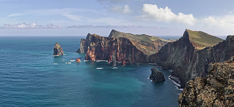
Deutsch: Ponta de São Lourenço, Madeira, Portugal. Blickrichtung Nord Nord Ost.
English: Ponta de São Lourenço, Madeira, Portugal. Heading north north east.
বাংলা: পোঁতা দে সাঁও লোরেসন্সু, মদিরা, পর্তুগাল। উত্তর উত্তর পূর্ব হতে ।
فارسی: پونتا د سائو لورنسو، جزایر مادیرا، پرتقال. این جزایر متعلق به کشور پرتقال است و در اقیانوس اطلس قرار دارد. |
| Aköl | |
| Tënëyök | Luɔ̈igup |
| Agɔ̈t | Richard Bartz |
| Kithiɛ̈c (Ke ber wëtmätkën looi) |
Apamduööt kän anɔng anyoothluɔi në anyoothluoɔi Creative Commons Attribution-Share Alike 3.0 Unported cök.
|
|
This image was selected as picture of the day on Wikimedia Commons for 1 March 2014. It was captioned as follows: English: Ponta de São Lourenço, Madeira, Portugal. Other languages:
Bosanski: Ponta de São Lourenço na portugalskom ostrvu Madeira. English: Ponta de São Lourenço, Madeira, Portugal. Русский: Побережье острова Мадейра в районе природного заповедника «Понта-де-Сан-Лоуренсу». বাংলা : পোঁতা দে সাঁও লোরেসন্সু, মদিরা, পর্তুগাল। উত্তর উত্তর পূর্ব হতে । 中文: 葡萄牙马德拉圣洛伦索角。 |
| Camera location | | View this and other nearby images on: OpenStreetMap |
|---|

|
This image has been assessed under the valued image criteria and is considered the most valued image on Commons within the scope: Western part of Ponta de São Lourenço. You can see its nomination here. |
This image has been assessed using the Quality image guidelines and is considered a Quality image.
|
Käthɛɛr ë makec
Tuenyë në aköl/akɔ̈licic apamduööt ɣoi kecit rɔt nyuɔɔth në akölic.
| Aköl/Akɔ̈lic | Riöpbundït | Thëmthëm | Dului | Këcïjaamic | |
|---|---|---|---|---|---|
| ee mënë | 15:36, 22 Pɛnëthiäärkurou 2013 | | 10,000 × 4,571 (5.28 MB) | Richard Bartz | Minor fix |
| 14:39, 22 Pɛnëthiäärkurou 2013 |  | 10,000 × 4,571 (5.28 MB) | Richard Bartz | == {{int:filedesc}} == {{Information |Description={{mld |de=''' Ponta de São Lourenço''' Madeira, Portugal. Blickrichtung Nord Nord Ost. |en='''Ponta de São Lourenço''' Madeira, Portugal. Heading north north east. |Source = {{Own}} |Date = 2013-112... |
Luɔi ë apamduööt
Cin apaam ye nuët lɔ wëtmätkën.
Luui ë yɔ̈rcïduut de pinynhom
Wiki kɔ̈k bɔ̈ looi makec kënë
- Luɔi be-tarask.wikipedia.orgic
- Luɔi bn.wikipedia.orgic
- Luɔi crh.wikipedia.orgic
- Luɔi cv.wikipedia.orgic
- Luɔi de.wikipedia.orgic
- Luɔi dsb.wikipedia.orgic
- Luɔi en.wikipedia.orgic
- User:Richard Bartz
- Wikipedia:Wikipedia Signpost/2014-03-05/Discussion report
- Wikipedia:Wikipedia Signpost/Single/2014-03-05
- User:JeffKobs
- User:Georgiarts
- Ponta de São Lourenço
- Frederico Cunha
- User:Morneo06
- Talk:Madeira/Archive 1
- User:BlueSentinel122/sandbox
- Wikipedia:Wikipedia Signpost/2022-05-29/Gallery
- Wikipedia:Wikipedia Signpost/Single/2022-05-29
- Luɔi en.wiktionary.orgic
- Luɔi es.wikipedia.orgic
- Madeira
- Isla de Madeira
- Wikipedia:Imágenes destacadas/Lugares/Europa
- Wikipedia:Recurso del día/701 - 800
- Anexo:Lugares de importancia comunitaria de Portugal
- Wikipedia:Candidatos a recursos destacados/Febrero-2015
- Wikipedia:Candidatos a recursos destacados/Ponta de São Lourenço north north east.jpg
- Wikipedia:Recurso del día/marzo de 2015
- Plantilla:RDD/756
- Wikipedia:Recurso del día/noviembre de 2015
- Wikipedia:Recurso del día/enero de 2018
- Wikipedia:Recurso del día/abril de 2020
- Wikipedia:Recurso del día/noviembre de 2022
- Luɔi eu.wikipedia.orgic
- Luɔi fa.wikipedia.orgic
Tïŋ luui de tëriëcëbɛ̈n juëckɔ̈k de apamduööt kënë.